
“All maps are flat” flerfs will say, usually to avoid showing a flat Earth map. Making a flat Earth map would be simple, using just a straight transformation of the terrain with the same scale everywhere.
In contrast, the scale on all maps of the actual Earth varies, as every map is a projection of a globe.
One map I’ve yet to hear a flerf comment on substantively is Admiralty Chart 4009, even though it’s the type of map flerfs should be familiar with.
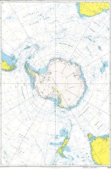
This would be the map (really a navigational chart) used to plan a route in the seas around Antarctica; the type of map that someone who is competent at celestial navigation would use. It’s a map that a flat earther would have a hard time arguing with.
- It shows the entirety of the of Antarctica, not as an ‘ice wall’, but as a continent.
- It show lines of longitude converging at 90° South, the South Pole.
- It shows that there is no more land beyond Antarctica, as some flerfs will claim.
So, they don’t argue with it, they ignore it and deflect from it.
Leave a Reply