
They’re just not maps of a flat earth.
All maps have distortions of scale affecting distances and angles between places. If the Earth were flat, Earth’s surface features would scale down without distortion. In fact the only non-distorted representation of the Earth is a globe.
Flerfs will often say that nobody uses a globe to navigate with. What size are they talking about? Let’s be generous and say a 30 cm diameter globe. A bit bulky for a car or aircraft cockpit maybe, but let’s see how that would work.
A 30 cm globe would be a 1 in 42,520,000 scale model; one cm would represent 425 km in real life1. In Britain, the most familiar maps in use are the 1:50,000 series, with 2 cm representing 1 km in real life. At that scale, a globe would have to be 850 times wider that our 30 cm model. That’s 255 metres so no, we won’t be using a globe to navigate.
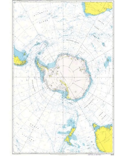
One flat map that Flerfs have to ignore is Admiralty Chart 4009. Admiralty Charts are produced by the UK Hydrographic Office at different scales according to need. They are used by navigators round the world (though electronic formats have largely taken over) to plot and chart courses between countries and continents.
Flerfs have to whistle past this. They swear that celestial navigation can only work on a flat earth. They agree that the latitude/longitude (spherical I must point out) coordinate system accurately locates positions on the earth; put this on a flat piece of paper and longitude lines radiate out from the North Pole, never to meet again.
Here is a map that they have a hard time disputing. It shows Antarctica as a continent, not an ice wall. It shows lines of longitude converging at the South Pole. It shows that the earth can not be flat.
- The Earth’s diameter is 12,756 km, or 1,275,600,000 cm. A 30 cm diameter scale globe model would therefore be a 1 in 1,275,600,000/30, or 1 in 42,520,000 scale model. ↩︎
Leave a Reply