Author: admin

  • Lines of Longitude Converge South of the Equator.

    The Greek astronomer Hipparchus is credited with specifying locations on the Earth using latitude and longitude in the 2nd century BC. It wasn’t until the 18th century AD that John Harrison produced the first timepiece good enough to enable marine navigators to get an accurate fix on their longitude.

    It’s safe to say that flat earthers and the rest of civilisation agree that the latitude/longitude coordinate system accurately maps locations on the Earth; after all, they make a lot of noise about celestial navigation proving the Earth is flat.

    So, can latitude and longitude be used to find out what shape the Earth is?

    (more…)
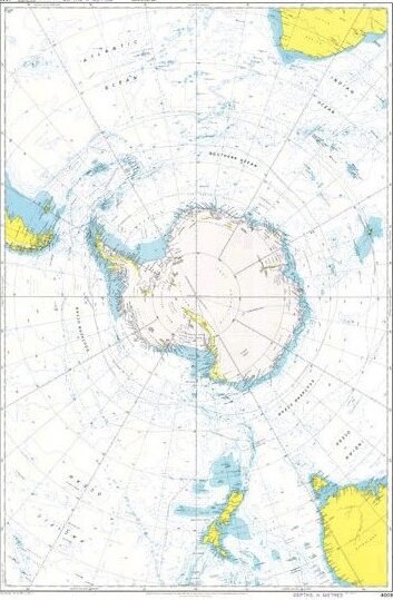
  • Admiralty Chart 4009

    All maps are flat” flerfs will say, usually to avoid showing a flat Earth map. Making a flat Earth map would be simple, using just a straight transformation of the terrain with the same scale everywhere.

    In contrast, the scale on all maps of the actual Earth varies, as every map is a projection of a globe.

    One map I’ve yet to hear a flerf comment on substantively is Admiralty Chart 4009, even though it’s the type of map flerfs should be familiar with.

    (more…)
  • Research “Fundamentals of Surveying”

    Flerf comment of the day:

    All elevations and elevation angles are measured from and use a horizontal, straight reference plane. You can research “Fundamentals of Surveying”.

    OK.

    S.K. Roy: Fundamentals of Surveying. Second Edition 2010.

    (more…)
  • Scott Adams

    Dilbert: You joined the “Flat Earth Society?”

    Dogbert: I believe the earth must be flat. There is no good evidence to support the so-called “round earth theory.”

    Dilbert: I think Christopher Columbus would disagree.

    Dogbert: How convenient that your best witness is dead.

    Scott Adams, cartoonist and author, 1957 – 2026.

  • All Maps are Flat

    They’re just not maps of a flat earth.

    All maps have distortions of scale affecting distances and angles between places. If the Earth were flat, Earth’s surface features would scale down without distortion. In fact the only non-distorted representation of the Earth is a globe.

    Flerfs will often say that nobody uses a globe to navigate with. What size are they talking about? Let’s be generous and say a 30 cm diameter globe. A bit bulky for a car or aircraft cockpit maybe, but let’s see how that would work.

    (more…)