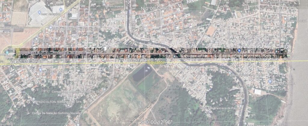
The Avenue Equatorial runs along the equator in Macapá, Brazil. We can use it to test ideas about the shape of the Earth. Anyone with access to Google Maps or similar navigational tools can verify this for themselves.
Beginning, End, and Length
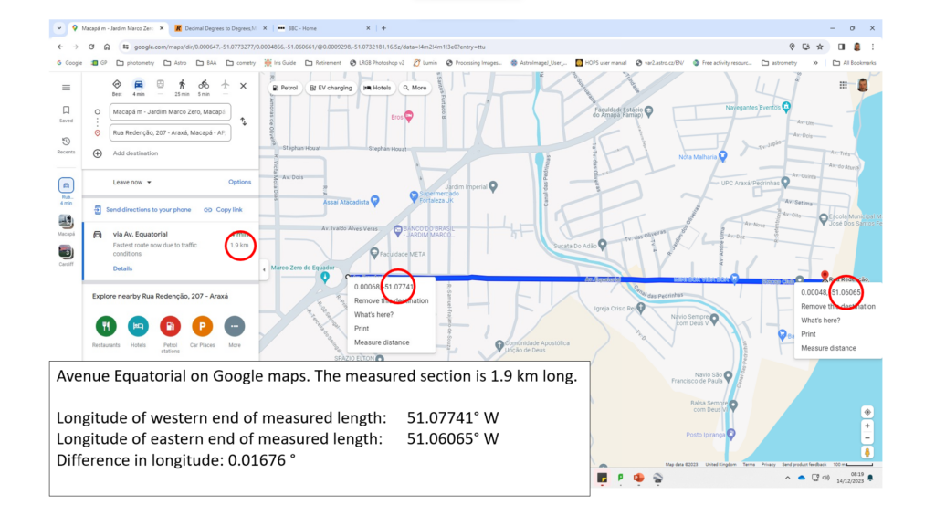
Using Google Maps, we can see that Avenue Equatorial runs along the Equator from longitude 51.06065°W to 51.07741° W. That’s a difference in longitude of 0.01676°. We also see that the length between the two points is 1.9 km[1].
As well as measuring the length using Google Maps (or indeed driving along the road and seeing what the odometer shows), we can work out what the length should be on a flat Earth. The maths for this should not be too taxing.
On a Flat Earth
The length of the circumference of a circle (such as the equator) is given by 2πr where r is the radius of that circle. On a flat Earth, the radius of the equator would be the distance from the equator to the North Pole, along a line of longitude. This is 10,000 km [2]. So on a flat Earth, the equator should be
2 x π x 10,000, or 62,832 km.
As we saw above, the Avenue Equatorial spans 0.01676°, which is a fraction of 1/21,480 [3] of the full 360° circle of the equator upon which it lies. It should therefore be 62,832 x 1/21,480 = 2.9 km long. Yet it measures, according to Google maps, 1.9 km. Why such a big error?
On a Globe Earth
On the globe, the radius of the equator is the distance from the equator to the centre of the sphere, not the North Pole. Rather than hunt for the value of the radius of the earth (it’s not hard to find), we can work out what it should be using our measurements above, and compare that to published values.
To work out the radius, given the change in latitude and the distance along the circumference measured, we need to rearrange the circumference formula, 2πr. We use r = c/2π; r is the radius, c is the circumference. c is going to be our distance measured times the fraction of the equator it represents, or
c = 1.9 x 21,480 = 40,812 km
Remember, the length of the equator on flat Earth would be 62,832 km. Our value of 40,812 km is certainly closer to the published value of 40,075 km [4], the value used by navigation systems round the world.
[1] Note that Google give distances to one decimal place. Many of the values above are given to multiple decimal places. It makes sense to round results to match what Google is showing, which is quite adequate for navigation.
[2] There are 90° of latitude between the equator and the North Pole. Using 1° latitude = 60 nautical miles (NM), we get a distance of 60 x 90 = 5,400NM. Using one of the many unit conversion websites (e.g.http://freeconvert.com) we get 10,000.8 km. In fact, the metre was originally defined as one ten millionth of the distance between either pole and the equator. It has since been refined, but I have for knocked off the additional 0.8 km ease of calculation. It makes an insignificant difference for our purpose.
[3] 360/0.01676 = 21,480.
[4] e.g. LibreTexts Geosciences
Leave a Reply